
Task Force 3: LiFE, Resilience, and Values for Well-being
Abstract
The impacts of climate change are being felt across the world, but countries of the Global South are disproportionately affected by geophysical hazards, inadequate and fragile infrastructure, supply chain deficiencies, and inefficient public health services. While such vulnerabilities are monitored in isolation, the imperative is an efficacious integration of independently measured vulnerabilities to create a composite Multidimensional Vulnerability Index (MVI), as proposed by the United Nations in 2020. Integrating datasets derived from monitoring vulnerabilities from ground- and aerospace-based platforms is a massive challenge, but it is crucial for preparedness against diverse socio-economic, geophysical and climate change vulnerabilities. In turn, preparedness will help alleviate the devastation from catastrophes and conflicts, and assist in recovery. This Policy Brief proposes that the G20 initiate a geospatial MVI Data Observatory to aggregate diverse satellite-based remote-sensing-generated vulnerability datasets and supply multidimensional, universal, exogenous, and standardised vulnerability indices. This observatory could aid governmental policies, enabling technology development and deployment and serving as a collaborative platform. The observatory would complement concepts such as Living for Environment (LiFE), One Health, and G20-2023’s ‘Liveable Earth’ goal.
1. The Challenge
The growing footprint of anthropogenic activity is bringing about microscopic and macroscopic changes in the Earth’s climatic systems, atmosphere, hydrosphere, lithosphere, and biosphere.[1] The impacts are spread across agricultural activities, rural and urban settlements and infrastructure, transportation, logistics and irrigation systems, potable water supplies, manufacturing activities, provision of commercial services, waste generation and management, disease control systems, and medical support, among other sectors.[2] So too, do changes in the environment—whether sudden and acute, or chronic and gradual—impact human activities.[3] Most vulnerabilities are localised, depending on the geology, geography, climate and weather, precipitation, hydrological features, and types of predominant anthropogenic activities of a region.[4] However, they can cause tremendous damage to lives, societies, cultures, and natural systems.[5]
The Global South has among the world’s most hazard-prone and vulnerable countries. Compared to those of the Global North, developing countries have denser populations and are highly susceptible to climate change hazards, geological hazards, infrastructure disruptions, supply chain disruptions, and weak public health systems.[6] The Humanitarian Assistance and Disaster Relief (HADR) needs of these economies are far greater than those of the Global North.[7] To address their social, economic, and natural security concerns, countries in the Global South need to pre-empt hazards, shocks and so-called ‘Black Swan’ events, and build disaster resilience into their governance systems, natural environments and infrastructure. This in turn calls for scientifically valid tools that provide data and information. Further, the tools and datasets need international validation and standardisation.
Scientists currently use various vulnerability indices to measure the differentiated vulnerabilities of every country to disasters, pandemics, climate change effects, conflicts, economic shocks and financial debts and other forms of distress, and infrastructural deficiencies. In particular, remote sensing data has been used to measure a variety of vulnerability indices—food security vulnerability,[8] coastal vulnerability,[9] forest vulnerability,[10] vulnerability index of mountains,[11] urban heat vulnerability,[12] social vulnerability induced by rivers,[13] desertification vulnerability,[14] and groundwater vulnerability along with its relation to water availability.[15] However, until 2020, what was missing was a composite vulnerability index that integrates multiple indices measuring economic, social and environmental parameters (see Fig. 1).
The COVID-19 global pandemic resulted in severe debt and strained financial circumstances for many nations. As a response, in 2020, the Small Island Developing States (SIDSs) set up the Alliance of Small Island States, with Belize as Chair, to press for urgent work on a multidimensional vulnerability index (MVI) to meet their specific concerns.[16] The alliance pointed out that there are better tools than the traditional measure of Gross National Income (GNI) to estimate allocation of concession finances to handle unforeseen and sudden catastrophic events or to service old debts. SIDSs have a low carbon footprint, contributing just 0.2 percent to global carbon emissions, but are among the most vulnerable to the impacts of climate change. The MVI, as envisaged by the SIDS, can be used for concessional financing to survive sudden climate catastrophes, servicing debts accruing after catastrophes, improving long-term national planning, and signing up for compensation and insurance schemes when sea-water levels rise.[17]
Climate change-related vulnerabilities in the Global South include heat waves, drought, flooding, reduced agriculture yield, labour productivity, cross-border migration, climate-induced conflicts, and ecological disasters.[18]
To be sure, the Global South is not a monolith; the newly industrialised economies of the region, such as China and India, have higher emissions than the others.[19] However, per capita emission, even in recently industrialised countries, including India, is still lower than in the Global North.
Some of the SIDSs have already initiated the MVI. The existing MVI model uses the following parameters:
- multidimensionality: the indicators in the MVI are drawn from economic, social, and environmental dimensions that are broadly accepted and equitable across the Global South
- universality: refers to the standardisation required to measure vulnerabilities across all Global South countries so that the data generated is comparable and credible
- exogeneity: the need to create data distinguishing between vulnerability factors inherent to Global South countries and those of external origin
- availability and readability: using comparable and reliable data while reducing estimations, preventing superfluity, and creating clear outputs for end users.
Figure 1. Vulnerability Types That Can Be Measured Under a Multidimensional Vulnerability Index
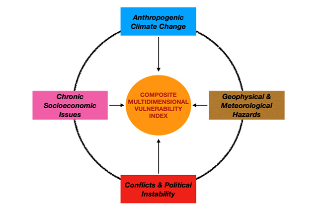
Source: Authors’ own, based on the UN Department of Economic and Social Affairs – Sustainable Development
Integrating remote sensing data fits all the five parameters of the MVI. Such data has been used to pre-empt, monitor, and detect various vulnerabilities, including geological hazards and climate change impacts. It has assisted in building national preparedness and resilience, supported HADR operations, and helped measure socio-economic indicators. However, the remote-sensing-based vulnerability indices mentioned have so far focused on environmental parameters. The G20 must initiate efforts to harmonise environment-oriented remote sensing and ground-based monitoring of vulnerability indices with social and economic datasets, especially around debt servicing, creating new economic measurements beyond GNI, developing climate financing mechanisms, monitoring and mitigating shocks like the COVID-19 pandemic, and building disaster-resilient infrastructure.
2. The G20’s Role
Since 2017, when Germany took over its presidency, the G20 has encouraged the conduct of disaster and climate-resilient infrastructure studies.[20] The G20 Hamburg Climate and Energy Action Plan for Growth, for one, cited the World Bank report, “Sovereign Climate and Disaster Risk Pooling – Joining Forces to Manage Climate and Disaster,”[21] which makes pertinent points about gathering risk information. The report states that lack of risk information (i.e., vulnerability information) can compromise investment decisions. Knowledgeable investment decisions come from better information. As this present Policy Brief points out, such information comes from continuously monitoring vulnerabilities and using the monitored data and information to make optimal decisions.
The World Bank report also pointed to the vast variations in catastrophe models, monitoring services and data from one region to another. It noted the need to standardise vulnerability monitoring, the data it generates and the services it offers. Such standardisation is necessary to provide equitable assistance to both the Global North and the Global South.
In 2018, with Argentina as G20 president, the G20 Adaptation Work Programme began, culminating in the G20 Action Agenda on Adaptation and Resilient Infrastructure during Japan’s presidency in 2019.[22] The efforts led to two noteworthy projects relevant to the theme of this brief. The “Building Resilience to Extreme Events in North America” project was executed by G20 member Canada and co-led by the United States and Mexico. It aimed at boosting preparedness and response to extreme events using remote sensing, improving local capacities in early drought warning systems, developing standardised methodologies to estimate the likely cost of extreme events in North America, and using observer networks to inform, predict, and monitor precipitation and wildfires. The project attempted to create a multi-vulnerability monitoring, preparedness and response system. The other project, titled “Climate Risk and Early Warning Initiative” led by Canada,[a] aimed at improving multi-hazard early-warning systems in SIDSs and least developed countries. The early-warning system is one component of creating a multidimensional vulnerability index.
A few initiatives have also been undertaken in different parts of the world to systemically measure vulnerabilities and resilience, aligning with the G20 Action Agenda on Adaptation and Resilient Infrastructure.[23] These include the G20 Climate Risk Atlas,[24] the UN Disaster Risk Reduction’s (UNDRR) Sendai Framework for Disaster Risk Reduction[25] and its Global Platform for Disaster Risk Reduction,[26] the multi-stakeholder Coalition of Disaster Resilient Infrastructure,[27] the UN Economic and Social Commission for Asia and the Pacific’s (UNESCAP) Risk and Resilience Portal of the Asia Pacific Disaster Resilience,[28] and the global Blended Finance.[29] These initiatives assist in developing comprehensive policies, generating knowledge and information products, undertaking capacity development, and mobilising finances.
3. Recommendations to the G20
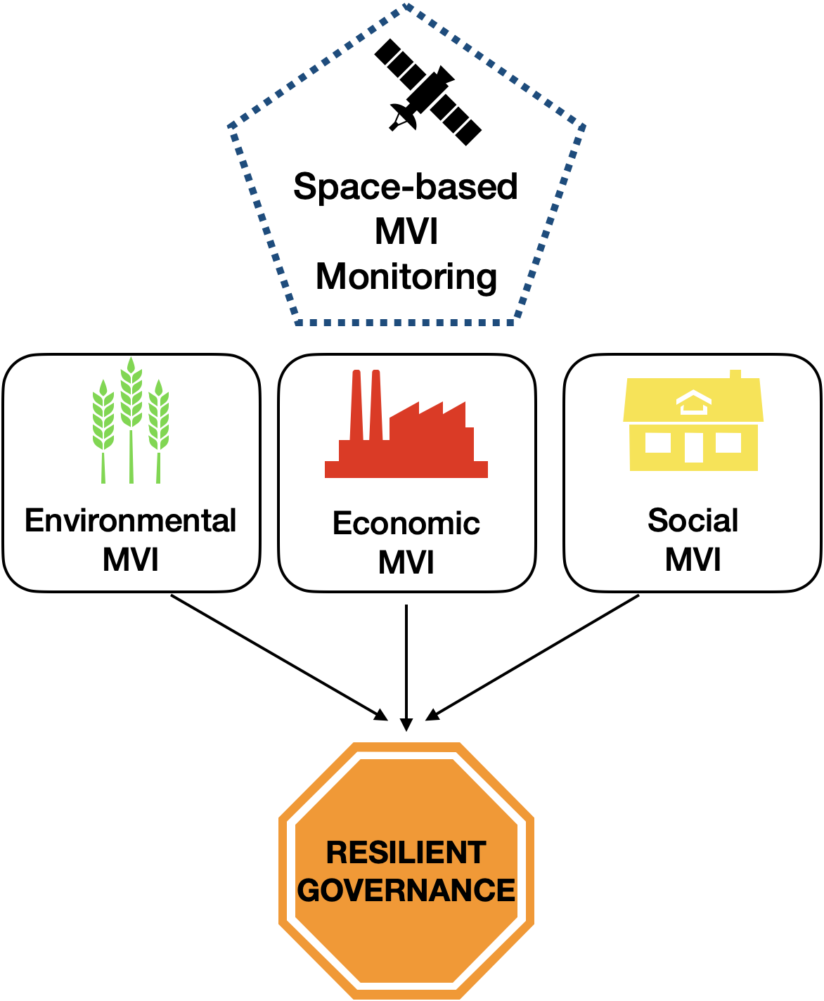
This Policy Brief recommends that the G20 lead the creation of a geospatial Multidimensional Vulnerability Index (MVI) Data Observatory. This virtual and digital observatory should operate in a system-of-systems mode, integrating various vulnerability datasets—environmental MVI, economic MVI and social MVI—gathered from multiple public-sector space agencies and commercial remote sensing satellite operators; and standardise the vulnerability measurement, monitoring, and output mechanisms for global use, particularly in the interest of the more susceptible Global South (see Fig. 2). The MVI Data Observatory would integrate the downstream satellite data for quantifying vulnerability dimensions such as:[b]
- Air quality indices;
- Geophysical hazard indices;
- Conflict and social unrest vulnerability indices;
- Meteorological vulnerability indices;
- Health system resilience and pandemic/epidemic resilience indices;
- Food value chain resilience indices;
- Potable water availability and quality indices;
- Food-water-energy nexus indices;
- Financial stresses and national debt;
- The extent of capital goods and infrastructure debt;
- The service life of infrastructure and its disaster resilience; and
- National and regional conflict diagnoses and assessment.
Figure 2. Space-based Geospatial Data to Monitor Environmental, Economic and Social Multidimensional Vulnerability Index and Ensure Resilient Governance
Source: Authors’ own, based on the UN Department of Economic and Social Affairs – Sustainable Development
As an output of the Bali Declaration during Indonesia’s G20 presidency in 2022, a Version 3 of the G20 Data Gaps Initiative (DGI-3) has been formalised, led by the International Monetary Fund (IMF). The DGI-1 was initiated in 2009 by G20 finance ministers and central bank governors in the aftermath of the global financial crisis that year. The DGI-2 commenced in 2015, ensuring regular collection and dissemination of timely policy-making statistics. The DGI-3 works on 14 recommendations, which include a few data gaps relevant to this brief. [30] These are:
- Accounting for greenhouse gases emissions and national carbon footprints;
- Monitoring the energy mix and intensities used by economic activities in production and consumption;
- Comparing the carbon footprint of foreign direct investments and domestic enterprises;
- Monitoring climate finance – green debt and equity security financing;
- Monitoring physical and transition risk indicators;
- Tracking expenditures incurred for climate change mitigation and adaptation;
- Comparing estimates to quantify subsidies by governments to tackle climate change; and
- Accessing private and administrative data, standardising shared data for research purposes, public-private cooperation, open data initiatives, and good data sharing practices.
These recommendations are congruent with the needs of the proposed MVI Data Observatory, as the latter, too, would require technical expertise in comprehending various types of satellite data gathered from multiple sources, sharing best practices, standardising output from datasets, and facilitating cooperation between countries to improve their domestic MVI monitoring and response networks. The G20 MVI Data Observatory could invite the participation of data and technology standards bodies while taking a cue from the G20 Data Gaps Initiative to help internationally validate and standardise the datasets and analytical tools. It could also be among the key drivers in providing technical support and guidance to Global South countries on policy development and capacity building, especially where data and technology standards bodies are yet to be established.
The G20 MVI Observatory could also be modelled along the lines of the existing Space for Climate Observatory—an informal multilateral whose members are space agencies, ecological agencies, scientific research institutions, and development institutions. The G20 MVI Data Observatory’s membership could span governmental and non-governmental scientific, economic and social research institutions belonging to the G20 members, G20 2023 guest countries, G20 permanent invitees, and representatives from other multilaterals and intergovernmental organisations.
The G20 currently collaborates with the Group on Earth Observations (GEO) – an intergovernmental body focused on coalescing remote sensing datasets from various public sector space agencies, and has recently begun on-boarding commercial remote sensing satellite operators as well. At present, the G20-GEO partnership is limited primarily to addressing food security issues, through a programme known as the Group on Earth Observations Global Agricultural Monitoring (GEOGLAM). The GEOGLAM is supervised by the UN’s Food and Agriculture Organization (FAO) through the Agriculture Monitoring and Information System (AMIS), initiated in 2011 when France held the G20 Presidency.[31]
The participation of the ‘G20 Compact with Africa’ and other multilateral institutions such as the African Union, the Association of South-East Asian Nations (ASEAN), the Arab League, SIDS, and the Commonwealth of Independent States (CIS) could be considered. This initiative could be one step beyond the existing MVI initiative by the UN Resident Coordinator Offices in SIDS.
Within the G20 Engagement Groups, setting up the G20 MVI Data Observatory could be tasked to the Space20 or the Space Economy Leaders’ Meeting. The national space agencies of the G20 nations and the guest countries should pursue the difficult task of integrating diverse satellite datasets to create the MVI, devise mechanisms to combine historical and real-time geospatial data gathered from public and private remote sensing satellites to create vulnerability maps, and then add multiple dimensions to make a geospatial-driven MVI. India’s Department of Space should consider taking stewardship of the G20 MVI Data Observatory.
The Department of Space already operates the UN-affiliated Centre for Space Science and Technology Education in Asia and the Pacific, primarily acting as an educational capacity-building institution serving countries from Asia and the Pacific. The Observatory, now with a mandate for the entire Global South, would work well with India’s space diplomatic outreach, its ability to work with diverse countries and country cohorts from the Global North and its natural affinity for the Global South. Another India-led global partnership, the Coalition for Disaster Resistant Infrastructure (CDRI), could be vital in translating the output of the G20 MVI Data Observatory, especially in making transport, health, urban infrastructure, power, and telecommunications infrastructure resilient, and improving current practices in capacity building, financing climate change mitigation and disaster recovery, and ensuring technical standards.
The output of the G20 MVI Data Observatory, working in partnership with the CDRI, would be beneficial to international development cooperation institutions, international financing institutions, regional multilateral institutions, trans-boundary infrastructure managing entities, banks, insurance companies, homeland security agencies, public health agencies, HADR agencies, national and international development policy institutions, among many other stakeholders.
4. Conclusion
A virtual and digital G20 MVI Data Observatory would offer wide-ranging and standardised MVI datasets and analytics tools to help with financial preparedness against geological hazards and climate change challenges, mitigating disaster events and aiding post-disaster recovery. The G20 MVI Observatory could systemically accumulate, process, and share end-user-ready satellite remote sensing data, including air quality data, gathered from national space agencies, and merge it with various non-geospatial dimensions to create a dynamic MVI map that national and sub-national governance bodies in the Global South could use to develop resilience against vulnerabilities. It will fill in the current gaps in the various scattered efforts undertaken by national governments and the United Nations in measuring vulnerability and creating indices.
The Global South’s public infrastructure and natural assets (including One Health) are deeply vulnerable to conflicts, economic and financial distress, meteorological and geological disasters, pandemics, industrial accidents, and socio-economic depression. The vulnerabilities are economic, social, and environmental, and countries have varying degrees of resilience. The G20-MVI Data Observatory could help prevent, mitigate, and alleviate the primary and secondary impacts of catastrophes or crises and ensure the well-being of the world’s vulnerable populations.
Attribution: Chaitanya Giri et al., “The Case for a Geospatial Multidimensional Vulnerability Index Data Observatory,” T20 Policy Brief, June 2023.
Endnotes
[a] And supported by Australia, France, Germany, Japan, Mexico and the Netherlands, along with the World Bank, World Meteorological Organisation and the UN International Strategy for Disaster Reduction.
[b] Some of these vulnerability indices exist presently. For example, the air quality and potable water quality indices are measured in most countries by the national government, and globally collated by the UNEP World Environment Situation Room. The Financial Stress indices are measured both by national governments and international bodies like the Asian Development Bank and the International Monetary Fund.
[1] Kai Fang, Reinout Heijungs, and Geert R. de Snoo, “Theoretical exploration for the combination of the ecological, energy, carbon, and water footprints: Overview of a footprint family.” Ecological Indicators 36 (January 2014): 508-518.
[2] T.V. Ramchandra, Bharath H. Aithal, and K. Sreejith, “GHG footprint of major cities in India.” Renewable and Sustainable Energy Reviews. 44 (April 2015): 473-495.
[3] Reinhard Mechler and Laurens M. Bouwer, “Understanding trends and projections of disaster losses and climate change: is vulnerability the missing link?” Climatic Change 133 (November 2015): 23-25.
[4] W.J. Wouter Botzen, Olivier Deschenes, and Mark Sanders, The Economic Impacts of Natural Disasters: A Review of Models and Empirical Studies. Review of Environmental Economics Policy 13 (June 2019): 2, doi:10.1093/reep/rez004.
[5] Renee M. Borges, “Of iconic animals and national pride: Whither restoration ecology in the Anthropocene?” Journal of Biosciences 47 (September 2022): 61, doi:10.1007/s12038-022-00304-4.
[6] Maud Borie, Mark Pelling, Gina Ziervogel, and Keith Hyams, “Mapping narratives of urban resilience in the global south.” Global Environmental Change 54 (January 2019): 203-213.
[7] Shreya Upadhyay, “India’s Disaster Relief Initiatives: From Neighbourhood’s First Responder to Regional Mobilizer.” Indian Foreign Affairs Journal 16, 2 (April-June 2021): 167-181.
[8] Saloua Rochdane, Lahouari Bounoua, Ping Zhang, Marc L. Imhoff, Mohammed Messouli, and Mohammed Yacoubi-Khebiza, “Combining Satellite Data and Models to Assess Vulnerability to Climate Change and Its Impact on Food Security in Morocco.” Sustainability, 6, 4 (April 2014): 1729-1746.
[9] Suzanne Mclaughlin and J. Andrew Cooper, “A multi-scale coastal vulnerability index: A tool for coastal managers?” Environmental Hazards 1 (June 2011): 233-248.
[10] David Mildrexer, Zhiqiang Yang, Warren Cohen, and David Bell, “A forest vulnerability index based on drought and high temperatures.” Remote Sensing of Environment 173, (February 2016): 314-325.
[11] Hongwei Wu, Bing Guo, Junfu Fan, Fei Yang, Baomin Han, Cuixia Wei, Yuefeng Lu, Wenqian Zang, Xiaoyan Zhen, and Chao Meng, “A novel remote sensing ecological vulnerability index on large scale: A case study of the China-Pakistan Economic Corridor region.” Ecological Indicators 129 (October 2021): 107955.
[12] Luis Inostroza, Massimo Palme, Franscisco de la Barrera, “A Heat Vulnerability Index: Spatial Patterns of Exposure, Sensitivity and Adaptive Capacity for Santiago de Chile.” Plos One, (September 2016): 10.1371/journal.pone.0162464
[13] Alexander Fekete, “Validation of a social vulnerability index in context to river-floods in Germany.” Nat. Hazards and Earth Systems Science 9, (March 2019): 393–403.
[14]Subramanian Dharumarajan, Thomas F.A. Bishop, Rajendra Hegde, and Surendra Kumar Singh, “Desertification vulnerability index—an effective approach to assess desertification processes: A case study in Anantapur District, Andhra Pradesh, India.” Land Degradation & Development 29, (November 2017): 150– 161.
[15] Ajay Kumar Taloor, Praveen K. Thakur, Md. Jakariya, “Remote sensing and GIS applications in water science.” Groundwater for Sustainable Development 19, (November 2022): 100817.
[16] United Nations, “History of MVI, from the UN Office of the High Representative for the Least Developed Countries, Landlocked Developing Countries and Small Island Developing States,” 2020, accessed on 28 March 2023.
[17] Bridi Rice and Shannon McKeown, “The Case for a Globally Accepted Vulnerability Index.” Center for Strategic & International Studies, 20 July 2022.
[18] UNCTAD, “Forging a Path Beyond Borders: The Global South.” 2018.
[19] Chad Jonathan Frischmann, Mamta Mehra, Jimena Alvarez, Emilia Jankowska, Heather Jones, Amrita Namasivayam, Abdulmutalib Yussuff, “The Global South is the climate movement’s unsung leader.” Nature Climate Change 12, (May 2022): 410-412.
[20] G20, “G20 Hamburg Climate and Energy Action Plan for Growth,” 2017, accessed on 28 March 2023.
[21] World Bank Group, “Sovereign Climate and Disaster Risk Pooling: World Bank Technical Contribution to the G20,” 2017, accessed on 5 May 2023.
[22] G20, “G20 Climate Sustainability Working Group Adaptation Work Program (2018-2019),” 2018, accessed on 28 March 2023.
[23] G20, “G20 Action Agenda on Adaptation and Resilient Infrastructure,” 2019, accessed on 28 March 2023.
[24] G20 Climate Risk Atlas, accessed on 28 March 2023.
[25] United Nations Office for Disaster Risk Reduction, “What is the Sendai Framework for Disaster Risk Reduction?”, 2015, accessed on 28 March 2023.
[26] United Nations Office for Disaster Risk Reduction, “Global Platform for Disaster Risk Reduction,” 2022, accessed on 28 March 2023.
[27] Coalition for Disaster Resilient Infrastructure, accessed on 28 March 2023.
[28] UN-ESCAP, “Risk and Resilience Portal – An Initiative of the Asia Pacific Disaster Resilience Network”, accessed on 28 March 2023.
[29] Bo Li, Fabio Natalucci and Prasad Ananthakrishnan, “How Blended Finance can support Climate Transition in Emerging and Developing Economies” International Monetary Fund Blogs, 15 November 2022.
[30] International Monetary Fund, “G20 DGI-3 Recommendations,” accessed on 15 May 2023.
[31] Chaitanya Giri, Abhilash Sethi and Amit Kumar, “Expand GEOGLAM to include Commercial Earth-Observation Entities: Attaining Global Agricultural Productivity and Food Security Beyond Four Staple Crops,” Task Force 4 Policy Brief – T20 Indonesia 2022.

